Ongoing Projects

Advanced Preemption Control Strategy Development and System Impact Evaluation of Deployed Applications (ATCMTD)

placeholder
Sponsor: USDOT/ATCMTD

This project is a subproject of the primary grant “Emergency Vehicle Preemption Using Connected Vehicle Technology” (Advanced Transportation and Congestion Management Technology Development (ATCMTD) Initiative Funding Opportunity No. 693JJ320NF00010). The overall project will provide the required roadside infrastructure and in-vehicle devices to support a Connected Vehicle (CV) deployment. This will include road-side units (RSUs), onboard units (OBUs), smartphones with integrated apps, and backend processing capabilities. This deployment will be a template for other locations with similar issues in the Metro Atlanta region and across the country. With these systems, field equipment will support V2I data exchange with emergency vehicles including Highway Emergency Response Operator (HERO) and the MetroAtlanta Ambulance Service which services Emory University Hospital Midtown. HEROs are dispatched to traffic related incidents in the Metro Atlanta region with the primary duty to clear roads so that normal traffic flow is restored. HEROs also assist stranded motorists with flat tires, dead batteries or in need of fuel or coolant. V2I data exchange will enable implementation of signal preemption which will assist these emergency vehicles in efficiently and safely traversing exit ramps and arterials. Signal preemption will reduce emergency vehicle travel times, saving precious seconds within the “Golden Hour,” in responding to incidents and returning to hospitals, ultimately saving lives. The overall project aims to build on these existing projects to reduce HERO response time to incidents, optimize ambulance travel time to Emory University Hospital Midtown, and improve pedestrian safety within the deployment area. The project will implement a Security Credential Management System (SCMS) to provide secure V2I communications between the RSUs and OBUs.

This subproject led by Georgia Tech (GT) will develop methodologies for the processing and analysis of CV and other data in real-time to support advanced preemption control strategies; create a digital twin of the connected corridor enabling real-time performance monitoring; and develop, test, implement, and evaluate forward-looking performance metrics. The evaluation of the project is a portion of the overall ATCMTD grant and represents on-going back-end development and evaluation throughout the entirety of the grant performance period.

Safe Trips in a Connected Transportation Network (ST-CTN)

placeholder
Image Credit: https://www.its.dot.gov/its4us/htm/publications.htm
Sponsor: ITS4US

The Safe Trips in a Connected Transportation Network (ST-CTN) project is led by the Georgia Department of Transportation (GDOT) with support from the Atlanta Regional Commission (ARC) in Gwinnett County, GA. The ST-CTN system will provide Gwinnett County residents with detailed information and step-by-step navigation tailored for users' specific needs along with a range of other features geared to improve trip efficiency and safety. This concept is comprised of an integrated set of advanced transportation technology solutions including connected vehicles, transit signal priority, machine learning, and predictive analytics to support safe and complete trips, with a focus on accessibility for those with disabilities, aging adults, and those with limited English proficiency. The ST-CTN system includes a mobile application that will provide users with the ability to create a personalized trip plan with information regarding the navigation of physical infrastructure, the ability to provide safe alternative trip routes when encountering unexpected obstacles, and ensuring users safety throughout the trip.

Strategy Analysis and Evaluation for Emergency Vehicle Preemption and Transit Signal Priority with Connected Vehicles using Software in Loop Simulation

placeholder
Sponsor: GDOT

The objective of this project was to develop and evaluate advanced strategies for Emergency Vehicle Preemption (EVP) and Transit Signal Priority (TSP) implementation that would incorporate and integrate real-time information from Connected Vehicles (CV), transit vehicles, traffic signal controllers, and other traffic detection technologies to improve overall performance relative to current practice.

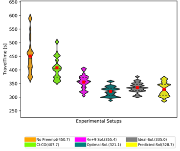
Task 01 of this study demonstrated the benefits of using EVP combined with CV technology, by developing a dynamic preemption (DP) logic and implementing it in a microscopic simulation model. DP, with either Normal or In-step exit transitions, led to an approximate 20% (~125 s) reduction in average travel time for an ERV when the ERV traversed through a series of eight preemption-enabled signalized intersections on a high-volume congested corridor. The DP algorithm provided a significantly larger reduction in travel time of the ERV than a traditional check-in-check-out detector-based preemption (~55 s) as compared to the no-preemption case. The non-ERVs sharing the same path as the ERV also received a significant reduction in delay as a by-product of preemption, primarily due to the queue flush in front of the ERV.

Task 02 developed machine learning algorithms to estimate optimal actuation times for EVP in the absence of complete real-time traffic state information that is feasible with CV and required for the DP logic. The ML-model based strategy developed here helps bridge the CV ramp up period gap by providing a methodology that works with the traditional data. The ML-model, trained using simulated data on the testbed, produced results that were better than the performance of the DP solution on the same ERV route.

Task 03 addressed the issue of the complex interactions between the general traffic and the ERVs. Realistic models are developed for driving behaviors for interactions between ERVs and non-ERVs which replicate the pull-over lane clearing behaviors that are observed in the real world in response to ERVs. The study generated External Driver Model dynamic linked libraries for Vissim® that can be integrated by others for preemption studies to integrate pull-over behavior in the models and provide a realistic baseline that will prevent an unrealistically optimistic bias in the results.

Task 04 studied the impact of TSP strategies. Overall, it is seen that TSP performance is most favorable in lower v/c conditions where far side bus stops are present and thus lower uncertainty in ETA, which is critical to TSP effectiveness. Compared to Early green, Green extension provides the most benefit to individual buses. However, as congestion increases the effectiveness of TSP decreases. On a highly congested corridor, i.e., v/c ratios approaching or exceeding 1.0, it is possible that TSP may become infeasible as the non-TSP movements may have insufficient slack in available capacity. The signal timing for optimal transit vehicle performance may not be optimal for other vehicles in the network. For instance, it was seen that slightly higher cycle lengths or adjusted offsets compared to those for demand based optimal signal settings may result in better TSP performance and lower impacts to non-transit vehicles during TSP events.

Recommendations

Using a dynamic logic for preemption is recommended under most circumstances where real-time traffic information is available. In cases where accurate queue estimates are not available from the field, ML models can be used to work with conventional vehicle detection data streams. Choice between normal and in-step exit strategies will need to take into consideration factors such as the demands and turn ratios at the intersections, the use of coordination on the relevant corridor, etc. Based on the findings from the pull-over modeling study an additional argument can be made for deploying EVP to avoid disruption to the traffic along the path of the ERV. It is clear that pull-over causes disruption to the traffic traveling in the same path as the ERV. The comparison of the non-ERV travel times between EVP and non-EVP scenarios, with pull-over integrated in the model, clearly shows that EVP can minimize the disruption with a relatively minor short-term disruption to the cross traffic. When considering the setting of TSP on a transit designated corridor: If intersections with a v/c ratio on the order of 0.95 or higher exist, it is recommended to consider slightly longer cycle lengths (on the order of 10 to 30 seconds) to determine if additional slack in the timing may be obtained. The general traffic delay will need to be checked, comparing the optimal cycle length vs transit cycle length, to determine the acceptability of this option. Where bus stops exist upstream of an intersection offsets that maximize the opportunity for bus passage should be investigated. Intersection dwell time distributions should be included in the modeling of the signal timing. In higher v/c situations where conflicting movement delay is highly sensitive to TSP, it may be desirable to limit TSP to GE as GE tends to higher benefits with lower impacts than EG. The selection of low (free flow) vs high (congestion based) estimated time of arrival (ETA) should be considered in relation to the corridor objectives. While free flow speed based ETA will likely provide overall better service, where the focus is on congested conditions, longer ETA may prove a more suitable option. Where possible, AVL (or other) solutions that allow for flexibility in the selection or application of ETA should be considered. While beyond the scope of a signal timing only effort, consideration should be given, where possible, to the placement of bus stops on the far side rather than near side of an intersection. Every corridor has unique characteristics, and thus each corridor should be modeled to determine the most effective application of these recommendations. However, key to the application of any transit timing is that transit timing be considered as part of the signal timing objectives rather than an afterthought to be applied by “tweaking” the general traffic “optimal” results.

Emergency Vehicle Signal Preemption Optimization

placeholder
Sponsor: Gwinnnett County

Georgia is at the forefront in the adoption of Connected Vehicle technology, leading the nation in large scale deployment of CV RSUs. Gwinnett County has identified the need for uniformity and coherence in the planning and deployment of CV infrastructure and has recently developed a Connected Vehicle Masterplan. The masterplan recognizes that the benefits of CV technology may not be achieved with the infrastructure equipment in isolation and has identified several CV applications that will not only improve safety and mobility directly through deployment but will also encourage involvement from the auto-manufacturers, fleet-operators, and automobile drivers in the deployment and use of OBUs in the vehicle that is essential for the benefits of CV technology to be fully realized. Emergency Vehicle Preemption (EVP) is one of the CV applications identified for deployment by Gwinnett County. EVP by itself is not a new technology and has previously been successfully deployed. However, the benefits of EVP has been somewhat restricted in the past, especially in congested roadway conditions, because of the line-of-sight requirement between the firetruck transmitter beacon and the preemption request receiver at the traffic signals. With CV equipment on board the emergency vehicles and CV RSUs connected to the signal controllers, the line of sight restriction is no longer required. This opens up the possibility of creating a free-flow path through the signalized intersections for the emergency vehicles. By anticipating the arrival of the emergency vehicle, based on its position as recorded by CV messages received at other RSUs in the system, vehicles on the approach of interest may be cleared before the emergency vehicle arrives at the intersection. While such a methodology has been proposed before and has seen limited implementation using GPS and cellular-phone based technologies, there is not sufficient literature on clear before-after evaluations of a distributed predictive EVP implementation. Research is also limited on the methodology of implementation. This study is proposed to fill these research gaps.

Utilization of Connectivity and Automation in Support of Transportation Agencies’ Decision Making

placeholder
Sponsor: STRIDE

Connected vehicles (CV), autonomous vehicles (AV), and connected automated vehicles (CAV) promise transformative changes in transportation system performance. Agencies need the capability to assess the planning, design, operations, and management implications of the presence of such vehicles with different levels of connectivity and automation on system performance. In addition, agencies need to assess the impacts of these technologies so that they can deploy them, or seek to inform or leverage their deployment, such that they improve the performance of the transportation system. This capability is particularly critical in the transition phase where a mixture of CAV’s and human-driven vehicles are likely to interact for at least the next decade or two and where there is insufficient real-world data to adequately guide such decisions. For decades, transportation system analysts have used modeling tools to estimate and forecast system performance. However, the introduction of emerging vehicle technologies such as CVs and AVs requires significant updates of and extensions to the existing tools and the development of a framework and guidance for the use of these tools. Researchers around the world are using simulation and developing new models to assess CAV impacts. Nevertheless, significant efforts must be marshalled to validate the existing work using field data, determine additional needed modifications and extensions to existing models, and develop new models and methods that reflect field performance of advanced vehicle technologies. In addition, there is a need to produce guidelines on the use of simulation tools in CAV evaluation to ensure that the models and tools are used in a consistent, robust and realistic manner. The research team will engage public and private agency staff and industry stakeholders to guide this research, to solicit field data, and to ensure dissemination and deployment of the guidelines and tools developed.

This project will identify, develop, and implement a suite of simulation models and methods for use in assessing the implications of the presence of connected vehicles (CV), automatous vehicles (AV), and connected automated vehicles (CAV) in the traffic stream and in evaluating the impacts of associated applications that use these technologies. The project will build on current national and international efforts including the on-going research conducted by the Federal Highway Administration (FHWA). As such, the research will start with a comprehensive review and assessment of the literature and existing products on the subject including examining the products of the FHWA effort. Using the review and assessment as a basis, high priority CAV applications to be addressed in this project will be identified based on defined criteria and a framework and guidelines will be developed for the use of analysis, simulation, and modeling of CAV. The project will then develop procedures for calibrating and validating simulation models to ensure the proper use of these models in replicating emerging vehicle technologies and applications. The research team will also identify and develop utilities and extensions of existing models to allow the modeling of selected high priority modeling applications. The project will demonstrate the use of the project development to support agency decisions with regard to high priority CAV applications.

Evaluating Sustainability Impacts of Intelligent Carpooling System among SOV Commuters

Sponsor: NCST

Community-based carpooling has a significant potential in alleviating traffic congestion and reducing carbon footprint. This is especially true during the peak periods because during the peak periods most of the trips are regular work-related commutes that are repetitive in nature regarding the start and end times as well as the origin and destination of the trips, thereby increasing the likelihood for pre-identifying carpool opportunities. Previous studies at Georgia Tech involving collection of on-road vehicle occupancy data revealed that during the peak periods, over 80% of vehicles are in ‘drive alone’ or single occupancy vehicle (SOV) mode. Other studies have identified that barriers deterring people from carpooling include demographic, communication, and economic barriers, among others. With the recent advancements in information technology and the wide proliferation of GPS enabled smartphones, a privacy-protected communication mechanism can be developed to seamlessly enable instantaneous formation of carpools and thereby release the hidden demands of carpooling trips.

The purpose of this study is to develop an analytical framework for assignment of individual vehicular trips into viable carpooling pairs under the constraints of a set of reasonable restrictions such as temporal and spatial bounds/limits, user preferences, etc.

Exploring a Novel Public-Private-Partnership Data Sharing Policy Through Developing a collaborative Arterial Traffic Management System

placeholder
Sponsor: C-TEDD

According to the latest Urban Mobility Report published by Texas A&M Transportation Institute (TTI), urban traffic congestion, mostly generated on urban arterials, is a persistently growing problem. In 2017, the total congestion cost in 494 U.S. urban areas was $166 billion and the extra travel time was 8.8 billion hours. Urban congestion is negatively affecting the economy and society of U.S.

To solve the problem of urban congestion, the University of Texas Arlington and Georgia Institute of Technology is collaborating to investigate a new Public-Private-Partnership (PPP) Data Sharing Policy through developing a novel arterial system performance monitoring and optimization system. The new system uses traffic data from both public agencies and private resources. In addition to the traditional traffic data sets, such as traffic counts or traffic signal events, crowdsourced vehicle trajectory data from private companies will also be included. The second focus of this research is to explore the unconventional optimization techniques for automated arterial system performance improvements. The arterial traffic performance monitoring and optimization are seamlessly integrated toward a highly automated arterial management framework to reduce the urban congestion and meet the future needs of travelers. These potential benefits of these two primary research thrusts will be demonstrated using an emergency vehicle application.

Development of Tools to Model Driver Behavior in a Cooperative and Driverless Vehicle Mixed Roadway Environment

placeholder
placeholder
Sponsor: GDOT

As the definitions of vehicles and drivers enter a constant state of change, the current state of understanding and analysis will no longer be sufficient. The objective of this research is to design a new simulation and modeling approach capable of reflecting emerging (e.g. aggressive) driver behavior in interactions with cooperative and autonomous vehicles using open simulation platforms (such as SUMO ‐ Simulation of Urban Mobility, Krajzewicz et al. 2012) that provide the flexibility lacking in current commercial platforms. This model will likely take a modular agent based simulation approach, where the vehicle types, behaviors, and abilities may be readily updated. Models must provide easily acceptable interfaces, allowing for data exchange with new agents. Modelers must have an ability to create agents (i.e., new drivers, vehicles, etc.) with diverse behaviors. For example, a driver willing to force a merge that requires a cooperative/autonomous vehicle (AV) to undertake significant deceleration to avoid a collision. With such a modeling tool, analysis into the ever changing technological environment may then be efficiently conducted. At present, a critical component in the determination of the impact of many of these technologies is the human interaction with the technology. However, the assumption that interacting non-AV drivers will be aggressive, without evidence to support this supposition, is no more valid than assuming behaviors will not change. Thus, a second objective of this research is to seek validation through surveys, focus groups, or field experiments of how changing vehicle technologies may influence driver behavior in these interactions. Of particular focus will be increased driver aggression. Aspects of driver aggression include excessive speed, frequent or unsafe lane changes, failure to signal, tailgating, failure to yield the right of way, and disregarding traffic controls.

The key objectives are:
  1. Design flexible simulation modeling approach with the ability to reflect the characteristics of the new transportation technologies rapidly being advanced. Key to this approach is the ability to:
    1. Insert new technologies in the modeling environment, as they become available, without the need to reconstruct the underlying model platform.
    2. Reflect potentially changing human driver behavior in interactions with cooperative and autonomous vehicles
  2. Develop interaction-behavior models between drivers and other autonomous/cooperative vehicles on the road (e.g. increased aggressiveness)

Past Projects

Impact of Smartphone Applications on Trip Routing and Congestion Management

Sponsor: Southeastern Transportation Research Innovation Development and Education Center (STRIDE)

Proliferation of mobile devices with routing apps such as Google Maps, Waze, INRIX, TomTom, etc. has made possible congestion avoidance through real-time re-routing of vehicles for any mobile-enabled driver. However, to date, the real impacts of these routing apps on system and local traffic across the roadway infrastructure are largely unknown. There is a limited amount of research that has broadly investigated issues such as the impact of social media on transportation policy (Gal-Tzur et al., Bregman and Watkins), usage patterns of smartphone apps (Jones et al.), and use of gaming concepts to influence driver behavior (McCall and Koenig, Wang et al.). However, there is a dearth of research investigating the impact of routing apps on trip routing or travel behavior. This study attempts to fill this gap and gather evidence and quantify the relationship between routing app usage and propensity of alternative route choices by routing app users.

Webinar [On Youtube]

Open Source Code [On Github]

Detection Technology Testbed on I-475: Technology Feasibility Evaluation

Sponsor: Georgia Department of Transportation

Traffic Management Centers (TMCs) have used Automatic Incident Detection with varying levels of success in past. The early detection tools used real-time traffic flow data based algorithms to identify anomalies in traffic. More recent automatic incident detection tools are based on real-time analysis of video streams. For instance, the Georgia Department of Transportation (GDOT) currently utilizes video analysis technology for the detection of stopped vehicles on shoulders and limited areas of active lanes. However, automatic incident detection technology has evolved rapidly in the last several years with significant improvements in video quality and computing resources. In light of the recent evolution in video based automatic incident detection technologies it is necessary to perform an evaluation of the feasibility of use of this technology by TMCs.

Surveys on the use of incident detection algorithms (Williams and Guin, 2007) have indicated a lukewarm response of the industry to automatic incident detection, primarily because of the false alarms generated by these algorithms. Similar observations have been made with video based automatic incident detection in previous studies (Caltrans, 2012) regarding the occurrence of false alarms. In addition, with the proliferation of cell-phones, manual detection based on calls from motorists have become the primary method of detection. Crowdsourced methods of detection using smartphone based apps is another detection method that has recently started making inroads into the detection process. However, there is still a relevance for automatic incident detection under low volume conditions where there are very few motorists available to make a report, in case the motorists involved in the incident are unable to make a call. Also, automatic incident detection can significantly cut down on the detection and reporting time, i.e. the time between the actual occurrence of the incident and the time when the TMC is notified about the incident.

The overarching goal of this project is to study the feasibility and potential benefits of a video based automatic incident detection technology (selected by the Georgia DOT) relative to the existing detection via the 511 incident reports and TMC Operators manual observations.

Operating Performance of Diverging Diamond Interchange

Sponsor: Georgia Department of Transportation

As the result of changing traffic patterns, many conventional intersections and interchanges can no longer accommodate growing traffic volumes and heavy turning movements. In response, there are various innovative intersection and interchange designs proposed and implemented to better accommodate these changes, and the diverging diamond interchange (DDI) is one of these alternatives. While there is a significant amount of research on the relative performance of DDIs and conventional diamond interchanges (CDIs), a clear set of guidance on demand conditions under which a DDI is likely an operationally more efficient solution is not readily available. This effort conducts a sensitivity analysis of CDI and DDI operational performance under various interchange lane configurations, including the selected study area of the Jimmy Carter Boulevard and I-85 interchange in Norcross, Georgia, under varying traffic demands and turn-movement ratios. The sensitivity analysis explores the detailed conditions in which one interchange configuration provides superior performance over the other. The sensitivity analysis is structured into a two-step process with a critical lane volume (CLV) analysis as the first step, followed by a VISSIM microscopic simulation study as the second step. Overall, the study found that a CDI is likely to be the preferred option at locations with traffic volumes well below capacity and cross-street left-turn traffic proportions below 30% of the total cross-street demand, and a DDI is likely to be preferred at locations with traffic volumes near capacity and cross-street left-turn proportions exceeding 50% of the total cross-street demand.

Increasing demands, along with the increasing fiscal, social, and environmental costs often associated with adding capacity, incentivizes utilizing innovative solutions to address today’s traffic challenges. The diverging diamond interchange (DDI) is one such infrastructure innovation. The DDI innovation is to flip the travel directions found on a conventional diamond interchange (CDI) cross-street bridge, eliminating several left-turn conflicts and reducing the number of signal phases required to two at the bridge end intersections. Through this innovative flow pattern, a DDI seeks to provide superior operational performance to a CDI where high numbers of left-turn movements result in interchange congestion (1).

This study performs a two-step sensitivity analysis of CDI and DDI operational performance under various interchange lane configuration and demand scenarios, seeking to provide guidance on demand conditions under which a DDI is likely to be an operationally more efficient solution. The two-steps are: 1) a critical lane volume (CLV) analysis; and 2) a VISSIM simulation study. Independent variables tested in the sensitivity analysis are traffic demand and turn-movement ratio, two critical variables in the operation of an interchange, with the primary measures of effectiveness (MOEs) as volume-to-capacity (v/c) ratio and average delay per vehicle.

Enhanced Role of Activity Center Transportation Organizations in Regional Mobility

Sponsor: Georgia Department of Transportation

This study reviews the practices on the emerging role of major activity center transportation organizations in enhancing activity center and regional transportation. A survey of the major activity centers in the United States was performed with respect to their role and activities in the operation of transportation systems serving the area. The survey indicated limited involvement of activity center transportation management organizations in traffic operations, primarily due to budgetary limitations. Three strategies were identified in this study for possible use by these organizations and a feasibility analysis was performed for each strategy. Feasibility analysis of the connected-vehicle parking management application indicated that it could be a successful strategy, where existing field deployments could be leveraged. The feasibility analysis of the tested predictive analytics based proactive traffic management strategy showed that this approach would need significant additional development before any field implementation. Feasibility analysis of the Do-Not-Block-the-Box Campaign strategy showed the most encouraging ready-to-deploy results. The nationwide survey indicated positive perceived results from the implementation of the strategy. An objective evaluation using a VISSIM simulation approach demonstrated that Do-Not-Block-the-Box Campaigns can provide improvements in mobility.

Energy and Environmental Impact of Truck-Only Lanes: A Case Study of Interstate 75 between Macon and McDonough, Georgia

Sponsor: Georgia Department of Transportation

Since heavy-duty truck operations can significantly affect traffic congestion, especially on road grade, the creation of exclusive lanes for trucks has been viewed as a potential alternative to reduce congestion delay, fuel consumption, and emissions. However, few studies have rigorously evaluated the effectiveness of truck-only lanes in achieving these benefits. This study demonstrates a model framework that combines a microscopic traffic simulation with emissions and microscale dispersion models to quantify the potential impacts of truck-only lanes on fuel consumption, emissions, and near-road pollutant concentrations. As a case study, the framework was used to evaluate a proposed $2 billion project to construct 40-miles of truck-only lanes on Interstate 75 (I-75) between Atlanta and Macon, Georgia (USA). The findings of this study suggest that truck-only lanes could significantly improve the traffic flow, and reduce energy, emissions, and pollutant concentrations. The research team expects that the extensive simulation results of this study help to understand the performance of truck-only lanes on a large-scale network with a heavy mixture of truck and general purpose lane traffic. The methodology and framework developed in this study can be effectively and efficiently applied to a wide variety of scenarios to evaluate the environmental impacts of other transportation projects under various conditions.

Integrating Intersection Traffic Signal Data Into a Traffic Monitoring Program

Sponsor: Georgia Department of Transportation

The objective of this study was to provide the Georgia Department of Transportation with an evaluation of the feasibility of integrating intersection traffic signal data into a traffic monitoring program. Some of the pertinent conclusions from this study are: Accuracy of 15-minute aggregates of vehicle counts is above 90% at a 95% level of confidence at majority of the study sites; Data quality at some intersections are affected by insufficient offset of the detection zone from the stop bar, leading to queuing of vehicles over the detector and resulting in over-counting of vehicles; and Data from intersections using video based detection are of comparable quality as other intersections using inductive loop detectors. For using the intersection signal detector data for traffic monitoring the following cautions need to be exercised: (1) Discard locations with data spikes i.e. detectors reporting more than 500 vehicles per lane per 15 minutes (threshold can be fine-tuned) at any single data-point. (2) Ensure stability of data connection for completeness of data at remote locations which use wireless data transfers. (3) Data availability does not guarantee data quality. Check plot of historical data for expected traffic patterns before considering use of data in traffic monitoring. (4) Use data from signal detector downstream of midblock location (i.e. use data from two intersections instead of one). (5) Use data from locations where the inductive loop detectors are physically located upstream of the beginning of turn lanes (if any). (6) Avoid locations where there is evidence (can be confirmed with site visit during peak period) of vehicles queuing over the detection zone. To improve the usability of intersection signal detector data for traffic monitoring it is recommended that for future installations and maintenance on existing detectors, detection zones are moved further upstream beyond the maximum queue length of a typical peak hour queue and beyond the beginning of the turn lanes. If it is not possible to move detections zones upstream of turn lanes, detectors should be installed on turn lanes as well. Based on the findings of the study, it is apparent that in majority of the cases, the intersection signal detector data is similar in quality to pneumatic tube count data in terms of both the mean and variability of the errors. However, there are two major concerns. Firstly, the intersection signal detector data does not provide classification data. If this is a major impediment in using the intersection signal detector data in traffic monitoring, this problem should be further investigated to identify possible solutions or workarounds. Secondly, as with any detection technology, the accuracy of the induction loop data feeding into the signal cabinets is dependent on the field deployment characteristics. While there is some variability in the level of error from site to site, in general following the intersection eligibility criteria guidelines should help ensure high quality of data for use in the traffic monitoring program. If the data from a particular site is expected to be used extensively on a long term basis, validation of the data via short term counts is recommended.

Centerline Rumble Strips Safety Impact Evaluation

Sponsor: Georgia Department of Transportation

Centerline rumble strips are used by various states as a low-cost countermeasure for mitigating cross-over crashes on two-way highways. This study performs a safety impact evaluation using an empirical Bayesian analysis. The researchers obtained a crash modification factor of 0.58, indicating a 42% reduction in crashes involving centerline crossings associated with the installation of centerline rumble strips. The sample size of fatal and injury crashes was too small to obtain separate crash modification factors for fatal crashes and injury crashes. The favorable crash modification factor (0.58) found in this study supports wider use of centerline rumble strips as a safety measure to address crashes involving vehicles that cross the centerline of the roadway.

Safety Evaluation of Roundabouts in Georgia

Sponsor: Georgia Department of Transportation

Several previous studies have documented significant safety benefits of roundabouts in the United Sates. However, the safety benefits for a given roundabout may vary depending on factors such as the familiarity of the driving population to roundabout operation, site-specific geometric features, weather conditions, etc. To help inform GDOT’s roundabout implementation investment decisions, the current study provides a safety evaluation of 27 Georgia roundabouts. A time-dependent form of the Highway Safety Manual predictive (empirical Bayes) method was used to estimate potential crash reductions across all crashes and all fatal and severe injury crashes. The findings provide further evidence that roundabouts are an effective crash countermeasure. Specifically, the results show the following crash reductions:

  1. A 37 to 48 percent reduction in average crash frequency for all crashes and a 51 to 60 percent reduction in average crash frequency for fatal and severe crashes at four-leg roundabouts converted from stop-controlled and conventional intersections
  2. A 56 and 69 percent reduction in average crash frequency for all crashes and fatal and severe injury crashes, respectively, at three-leg and four-leg roundabouts converted from stop-controlled and conventional intersections

The study did not consider five-leg roundabouts due to small sample size and concerns about the form of the SPF.

Operational Evaluation of Do Not Block The Box Campaigns In Georgia

Sponsor: Georgia Department of Transportation

This project provided the Georgia Department of Transportation (GDOT) and the Perimeter Community Improvement District (PCID) with an evaluation of the operational performance impacts of implementing a “Do Not Block the Box” (DBTB) campaign at selected signalized intersections. For the studied sites, the likelihood, or propensity, of a vehicle to block was measured both before and after the DBTB treatment installation. Several blocking behavior characteristics were seen throughout the analysis. First, the change in propensity with the installation of the DBTB treatment was inconsistent, witnessing both increasing and decreasing blocking rates. However, regardless of an increase or decrease in blocking rate, the aggregated observed propensities at the studied intersections were consistently high in both the before and after treatment conditions. The lowest observed aggregate propensity to block was 55%, with all other time periods above 60%, and with half of the observed periods having a propensity to block of 70%. In addition, there was significant variability in day-to-day blocking opportunities. While the current treatment as a standalone measure did not meaningfully impact blocking behavior, there is significant value in continuing to seek reductions in blocking behavior. Based on the study findings and field observations during the data collection, several recommendations are offered in this report.

Evaluation of Cost-Effectiveness of Illumination as a Safety Treatment

Sponsor: Georgia Department of Transportation

Late-night and early-morning driving periods have significantly higher incident and fatality rates than other periods of the day. Many of these crashes occur at rural intersections and intersection illumination provides a proven safety countermeasure to help ameliorate these risks. However, intersection illumination remains one of the main contributors to electrical power consumption in roadway maintenance and operations. This study seeks to provide a better understanding of the relationship between illumination and crash occurrence at rural intersections and to synthesize this understanding as guidance for transportation agencies to determine how and when illumination is cost effective. The findings from this research is expected to significantly aid GDOT and other State DOTs to objectively determine if a rural intersection should be illuminated or if safety objectives can be met with reduced illumination level. This knowledge will aid engineers in making effective design and operational decisions that are cost effective without compromising desired safety goals. Additionally, this study will provide summary of the best practices and provide recommendation for practitioners as to the most cost-effective approaches.

Freeway Travel Time Estimation and Forecasting

Sponsor: Georgia Department of Transportation

Real-time traffic information provided by GDOT has proven invaluable for commuters in the Georgia freeway network. The increasing number of Variable Message Signs, addition of services such as My-NaviGAtor, NaviGAtor-to-go etc. and the advancement of the 511 traffic information system will require the Traffic Management Center to provide more detailed and accurate traffic information to an increasing number of users. In this context, the ability to forecast traffic conditions (both in space and time) would augment the services provided by NaviGAtor by allowing users to plan ahead for their trip. Forecasts built into the estimation model will make the travel-time estimates more accurate by reducing the use of stale data. Additionally, spatial forecast can help GDOT provide reliable information in areas with temporary outages in coverage; e.g. outages due to detector or cameras malfunction.

The vast majority of real-time travel-time estimation algorithms proposed in the literature are based on data mining techniques. Unfortunately, this approach is unable to produce reliable forecasts because it does not take into account traffic dynamics (e.g., via a simulation model). In Germany, a simulation-based forecast system is in place at most metropolitan areas, with very favorable user impacts. Although successful, the German example is based on a type of simulation model (a Cellular Automata model) that has critical drawbacks: difficulty of calibration, inability to incorporate different user classes (e.g., cars and trucks), and inadequate capability of replicating detailed traffic dynamics on freeways. The model proposed in this study overcomes these drawbacks by incorporating the latest advances in traffic flow theory and simulation.

This study demonstrated the use of a simulation based framework to make short-term travel-time predictions in real-time. The results show that sufficiently accurate 5-minute and 10-minute predictions can be made using this framework. The lessons learned from the study stresses that it is critical to adequately calibrate the simulation model and for this purpose it is essential to accurately calibrate the vehicle detection sensors. Currently, the simulation is manually initiated each time a new OD matrix becomes available. For a seamless implementation, the initiation process needs to be automated. In future studies the researcher would like to automate the simulation to run continuously by getting sufficient predictions from a run, pausing the simulation until the next OD update is available, and updating the OD flows and initial queues. When incidents occur, the corresponding lane blockage can be incorporated in the simulation before predictions are made.

Development of Optimal Ramp Metering Strategies

Sponsor: Georgia Department of Transportation

The objective of this study was to optimize the parameter settings for the local ramp metering control system currently in operation in the Metro Atlanta freeway network. The study corridor was the Eastbound/Southbound segment of I-285 between GA 400 and I-20. Using a stochastic simulation-based optimization framework that combines microsimulation model GTsim and a genetic algorithm-based optimization module, we determine the optimal parameter values of the ramp-metering control system. We generate optimal ramp metering values for 11 ramp-metering locations. The results of this project are expected to improve ramp metering efficiency and mitigate freeway congestion.

Implementation of Optimal Parameter Settings in GDOT’s Current Ramp Metering Operation

Sponsor: Georgia Department of Transportation

The objective of this project was to optimize the parameter settings for the ramp metering control systems in operation on the EB/SB I-285 study corridor between GA-400 and US-78. This study was accomplished with the simulation-based optimization framework GTsim, modified to account for the existing control system configuration. The project developed parameter settings for the MaxView software that GDOT acquired for the freeway and arterial signal management.

We found that each local ramp metering system hasdifferent critical density values,soit needs to be optimized carefully. This study analyzed extensive traffic data to generate origin-destination (O-D) flows of the study corridor. We used tube counters (flow) data for on-and off-ramps and NaviGAtor (flow and speed) data for the mainline freeway to estimate travel time of each O-D.

This study also developed a Genetic Algorithm-based optimization method to generate optimal parameters of the RM system. We found that optimal RM reduces almost 5 % of total travel time compared to the current control method. These savings are not trivial considering that the upstream sections of the corridor (near Peachtree Industrial Blvd and North Peachtree Rd) gets completely congested by the end of the rush hour period.Since many ramps of the study corridor operate at minimum rate after a certain time, it is safe to saythat most of the benefits of parameter optimization are realized during the congestion build-up phase. From the optimal parameter and the critical density, we generated recommended metering rates for each location, which GDOT can readily implement in MaxView.

Travel-time Optimization on I-285 with Improved Variable Speed Limit Algorithms and Coordination with Ramp Metering Operations

Sponsor: Georgia Department of Transportation

The objective of this project is to develop effective Variable Speed Limit (VSL) control algorithms to minimize the total travel time on EB/SB I-285 study corridor between GA-400 and US-78. Thisobjective was accomplished with a simulation-based optimization framework using the GTsimmicrosimulationapplication, which allowsus to optimize the coordinated operation of VSL control with the existing ramp metering (RM) control, and to forecast travel times to improve the efficiency of VSL control. Extensive traffic data for the study corridor were collected and processed for calibration.

We found that the current GDOT VSL algorithm is unable to improve travel times, even using the optimal parameters found in this project. The main reasons is that thecurrent algorithm was designed in order to harmonize the speed of traffic flow, which is the standard approach worldwide. However, this approach has not been shown to improve freeway capacity, and the travel time savings reported in the literature (~5-10%) come from incident reductions.

We propose a new combined VSL-RM algorithm designed to maximize freeway capacity by avoiding the capacity drop phenomenon at merge bottlenecks. It is found that the new algorithm is effective in preventingacapacity drop in that the ensuing travel time savings are significant compared to the ramp-metering-only option. The optimal speed of the VSL-RM algorithm was formulated from shock wave theory and experimented using GTsim.This study analyzed extensive traffic data to generate origin-destination (O-D) flows of the study corridor. We used tube counters (flow) data for on-and off-ramps and NaviGAtor (flow and speed) data for the mainlinefreeway to estimate travel times for each O-D. This study also developed GA-based optimization method to generate optimal parameters of the proposed VSL-RM algorithm. We found that the proposed VSL-RM algorithm reduces the total travel time by 8% comparedto no control and 15% compared to GDOT’s current algorithm.

From the analysis and results of this study, we recommend GDOT to revise the current VSL algorithm to incorporate other traffic features (density, flow, and capacity) so that the proposed VSL-RM can contribute improving capacity of the freeway and reducing travel time.Then, the B/C ratio of the updated system can be assessed with standard methods but based on this study we estimate that it should be in the range of 200:1 due to the low implementation cost.

Metro Atlanta Performance Report

Sponsor: Georgia Department of Transportation / Georgia Regional Transportation Authority

The Transportation MAP (Metropolitan Atlanta Performance) Report was initiated in 2003 by a group of regional agencies with the objective of documenting current developments, trends, achievements and issues with Metropolitan Atlanta’s transportation system. The agencies tracking the measures in this report are the U.S. Department of Transportation, GDOT, the Environmental Protection Division (EPD) of the Georgia Department of Natural Resources, ARC, GRTA, and MARTA.This report summarizes measures grouped in six areas: Mobility, Transit Accessibility, Air Quality, Safety, Customer Satisfaction, and Transportation System Performance.

Georgia Tech assisted GRTA with compiling the Mobiliy Section of the Report.

Feasibility Study for Video Detection System Data to Supplement Automatic Traffic Recorder

Sponsor: Georgia Department of Transportation

The objective of this study was to determine the feasibility of incorporating Georgia NaviGAtor traffic volume data with Georgia Department of Transportation (GDOT) traffic volume data to enhance federal reporting. Some of the pertinent conclusions from this study are: (1) Accuracy of video detection system (VDS) counts varied from site to site and lane to lane. (2) Accuracy for VDS with gantry-mounted cameras was not significantly better than that of pole-mounted VDS sites. (3) Accuracy of VDS sites with cameras mounted on 36 ft. offset poles was marginally lower than units with cameras mounted on 24 ft. offset poles. (4) Accuracy of counts from VDSs and remote traffic microwave sensors (RTMSs) is sensitive to site-specific deployment characteristics. (5) There is a likely limit to the number of lanes that may be accurately counted by a single VDS unit. (6) Counts aggregated over all lanes provide the highest accuracy. (7) Given the variability in data quality across detection stations, the use of VDS data to supplement GDOT data should be considered on a detector-by-detector basis (i.e. the data from a detector need to be individually checked for quality against ground truth data before they are used for federal reporting purposes).

Smart Cities Atlanta - North Avenue and Special Event Demonstration Project

Sponsor: Georgia Department of Transportation

To achieve the vision of leveraging information sharing between vehicles and the infrastructure to enhance mobility and safety, the USDOT is supporting on-road deployment and testing of Connected Vehicle technologies. The field deployments of CV technology to this point have mostly been state-led and consist primarily of Road Side Units. While the penetration of On Board Units is expected to increase over the years, it will require many years before saturation is achieved. This study assesses feasibility aspects of using a real-time data-driven transportation simulation model to generate synthetic realistic Basic Safety Messages that enable the computation of performance metrics that would otherwise be infeasible, and thereby provide a bridge over a low CV penetration scenario to a high CV penetration environment. This helps the evaluation and visualization of network performance indices to provide dynamic operational feedback in a real world environment, in a connected vehicle context. In this study, a real time data driven traffic simulation model, is developed that is capable of adapting to a mixed reality environment by filling in the data gaps that are typical in such a high speed data scenario. The hybrid model represents a traffic corridor equipped with smart devices generating high velocity, high volume datasets with limited shelf-life. Signal controls and vehicle volumes at the intersections are driven by real-time data. An optimized architecture is developed to enable control of the signals and the vehicle volumes using real-time data from in-field detectors, and real-time processing of the vehicle trajectories from the simulation output to generate travel-time, energy, and emissions performance indices.

Roadmap for Driverless Vehicles

Sponsor: Georgia Department of Transportation

This study develops a technology roadmap of the development of driverless vehicles, exploring the likely impacts for the transportation systems of the state of Georgia and the operations of the Georgia Department of Transportation (GDOT). The roadmap consists of two elements. First, a range of contingencies shaping the development pathways for autonomous vehicle (AV) technology is examined through: (a) a review of literature in the research and professional communities regarding AV, and (b) semi-structured interviews with 31 industry and public-sector experts representing a range of development strategies and commercial applications. Second, a range of impacts from AV technology on the transportation systems of Georgia is identified through focus groups with GDOT leadership, managers, and consultants representing the full scope of GDOT operations. By comparing findings between the two elements of the roadmap, implementation strategies to prepare for and manage the deployment of driverless vehicles are developed. Drawing from knowledge gained through these resources, five classes of recommendations were developed that address the following areas of implementation: (1) Developing an Internal AV Organizational Structure; (2) Increasing GDOT Familiarity with AV Technology; (3) Managing External Engagements Related to AV Technology; (4) Data, Analysis, and Performance Indicators for AV Technology; and (5) Managing Outside Activities.

Cooperative Vehicle-Highway Automation Technology: Simulation of Benefits

Sponsor: Georgia Department of Transportation

The past few years have witnessed a rapidly growing market in assistive driving technologies, designed to improve safety and operations by supporting driver performance. Often referred to as cooperative vehicle–highway automation (CVHA) systems, these assistive technologies commonly utilize radar, light detection and ranging (LiDAR), or other machine-vision technologies, as well as vehicle-to-vehicle (V2V) and vehicle-to-infrastructure (V2I) technology, to obtain surrounding roadway and traffic data. Extensive research has been conducted on CVHA technology since the late 1990s. Findings have been generally positive, including potential safety benefits, high potential acceptance rates, and reductions in driver workload, though operations and capacity impacts have been mixed, depending on the technology. Numerous opportunities for further advancement in traffic control strategies that leverage V2V and V2I have been identified and are under development. However, from the current literature, it is not clear: (1) how some of these systems will operate on the existing infrastructure (e.g., autonomous vehicles), (2) how they will impact traffic congestion and safety, and (3) how state departments of transportation (DOTs) should incorporate this changing vehicle and driver environment in their planning, design, safety, and construction processes. The objective of the current study was to begin to address these concerns to ensure that state DOTs and other practitioners will have the information necessary to make effective policies, procedures, and management decisions regarding CVHA technology. In seeking to address these concerns, a key finding from this study is related to the underlying modeling approaches utilized to study many of these potential technologies. It viii is clear that current simulation models are not capable of readily modeling cooperative assist technologies or autonomous vehicles. A critical component in the determination of the impact of many of these technologies is the human interaction with the technology, both those individuals inside the equipped vehicle and those driving other vehicles that interact with the equipped vehicle.

Real Time Estimation of Arterial Travel Time and Operational Measures Through Integration of Real Time Fixed Sensor Data and Simulation

Sponsor: Georgia Department of Transportation

A wide variety of advanced technological tools have been implemented throughout Georgia’s transportation network to increase its efficiency. These systems are credited with reducing or maintaining freeway congestion levels in light of increasing travel demands. In Georgia these benefits are primarily gained through the Traffic Management Center’s freeway monitoring and quick response in ridding the roadway of any obstacles that may reduce freeway service levels. There have been a number of efforts to leverage the work done by TMCs to provide travelers with more current traffic information such as Georgia 511 and Navigator. In addition, private efforts and partnerships have made the TMC’s information more accessible to travelers, aiding their traveler decisions. The effort presented in this report aims to compliment real-time freeway information by addressing the more limited availability of real-time arterial performance measures.

Work Zone Technology Testbed

Sponsor: Georgia Department of Transportation

In this research project, travel time data collection technologies were reviewed and three different technologies, Bluetooth®, Automatic License Plate Recognition (ALPR), and iCone® system, were selected for field testing deployment in Metro Atlanta. After successful initial testing in controlled conditions, the systems were deployed into I-285 freeway work zones and real-time travel time data were collected. This research project evaluated the capability of the selected technologies to provide accurate realtime travel time information. The data from the systems were selectively compared with travel time data collected via manual means. The selected technologies were found to report reasonably accurate travel time data in free flow conditions and congested traffic conditions. However, travel times derived from all three methods were biased toward collecting more data from slower moving lanes during congested traffic conditions. As such, work zone travel times were biased high from all three methods. However, the overall results showed that all three methods are technologically feasible, and biases can be overcome with proper equipment placement and deployment configurations.

Network Performance Monitoring and Distributed Simulation to Improve Transportation Energy Efficiency

Sponsor: Advanced Research Projects Agency–Energy (ARPA-E)

Transportation accounts for more than 25% of total energy consumed in the United States. Efforts to minimize energy use have predominantly focused on improving vehicle fuel efficiency and expanding use and availability of public transit. However, other factors impact transportation energy use such as traffic congestion, stop-and-go traffic, and limited information on available routes. Now, due to increasing availability of real-time data on traffic flows, transit scheduling, parking, local weather, and activities linked to transportation use, it is additionally possible to empower individual travelers to meet their transportation needs in ways that reduce energy use. To address these opportunities, new methods of modeling real transportation networks, new network optimization approaches and personalized incentive strategies can be used to deliver individuals the information they need to make choices that provide them with quality of service while reducing energy utilization in our transportation systems.

Researchers with the Georgia Tech Research Corporation will combine real-time analysis of transportation network data with distributed simulation modeling to provide drivers with information and incentives to reduce energy consumption. The team's system model will use three sources of data to simulate the transportation network of the Atlanta metro area. The Georgia Department of Transportation's intelligent transportation system (ITS) data repository, hosted at Georgia Tech, will provide 20-second, lane-specific operations data while team partner, AirSage, will provide highway speeds and origin-destination patterns obtained from cellular networks. The team will also use real-time speed data collected from 40,000 volunteers using a smartphone application. The researchers will use pattern recognition algorithms to identify traffic accidents and recurrent congestion, predict traffic congestion severity, and user responses to congested conditions. Using this information, the team will develop a control architecture that will signal drivers with options to alter departure times, take specific routes, and/or use alternate modes of transportation to reduce energy use. The team anticipates that users will adopt the suggested guidance because the suggestions identified will not increase the time or cost of the trip, and could ultimately save users money in fuel costs